Non precision RNAV approach, what could be simpler? Follow the GPS course, descend to MDA and look for the airport. One thing that I like about aviation is that you can often find many layers behind a simple concept and that it pays off to study them at home.
Simple non-precision approach
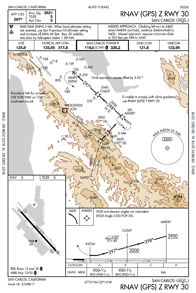
Consider a simple RNAV approach to runway 30 at my home airport SQL. You typically get vectored to AMEBY, descend to 2000 feet at FAF (CUZUP), continue descend to 900 feet and look for the runway approaching the MAP (KIZEM). Simple, right?
We had really bad fires in Northern California fall of 2018 and the wind blew massive amount of smoke. Coming back to San Carlos, you look at that gray mass below you that you are soon to breathe while still in clear skies at 8,000 feet and listen to ATIS: Wind calm, visibility 1.5 miles, sky clear. So much for a VFR descent, the field is IFR.
You briefly consider asking for special VFR (remember that one, right?), but the thought of flying into and through that smoke VFR is not particularly enticing. You can barely see the ground below you, but nothing in front, let alone any traffic around. You would need to ask Norcal Approach for the special, since you would have to fly through class E with below-VFR visibility. Can they even give you special 15 miles away from the airport?
No, you decide to exercise your hard earned instrument rating and request an approach. SQL has two approaches, RNAV Z and RNAV Y and they look awfully similar. Why there are even two? You check MDAs and see that Z has MDA at 900 feet (we will ignore any NOTAMs for now), while Y is 1260 feet. Really weird, isn’t it? Why publish an approach with higher minimum at all? (Bonus points if you find it out). You smugly ask for and get RNAV Z. All is good as you descend to AMEBY, where you even get a glidepath. It is a non-precision approach, but your Garmin box happily calculates required glidepath and annunciates LNAV+V. It is advisory only, but it is still a glidepath, so let’s glide down. You pass CUZUP, level off at 900 and approaching KIZEM you look.
You look hard, you look, and you keep looking, looking, looking and right as you arrive at the MAP, here it is, the airport. Except that it is awfully low, or rather you are awfully high and even being a hardened flyer as you are, you can’t pretend that a descent to a landing on the intended runway can be made at a normal rate of descent using normal maneuvers (FAR 91.175(c)(1)). You are in a Cirrus, so you could pull a parachute and that would get you to touchdown on the first third of the runway, but you are not sure if FAA and your insurance company would consider that a normal maneuver. Time to go missed, full power, climb, back to AMEBY.
What went wrong and what could you do better?
VDP
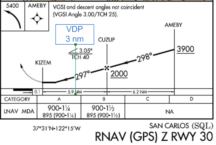
To fix the problem, we first have to recognize it. In this case, the problem is not enough time to descent and this is why the concept of Visual Descent Point (VDP) was defined. It is a point at which, if you don’t see the runway, you might as well go missed, because you will not be able to descend using normal maneuvers. Many approaches have charted VDPs, but RNAV Z 30 SQL does not. This shouldn’t prevent you from computing one for yourself. At 500 fpm, you will need 2 minutes to descend from 900 feet (I am using approximate math, but it is easier than real math), in a Cirrus you are doing 1.5 nm/minute (90 knots), that’s 3 miles. Another shortcut is to multiply your height by 300 (900 x 300 = 2.7 miles, close enough), that works for 3 degree glidepath.
With visibility of 1.5 miles, you will really need very sharp eyes to see that runway at three miles out. What you should have done is to to annotate the approach plate with your own personal VDP. Looking at the plate it would have been obvious that RNAV Z with straight in wouldn’t work.
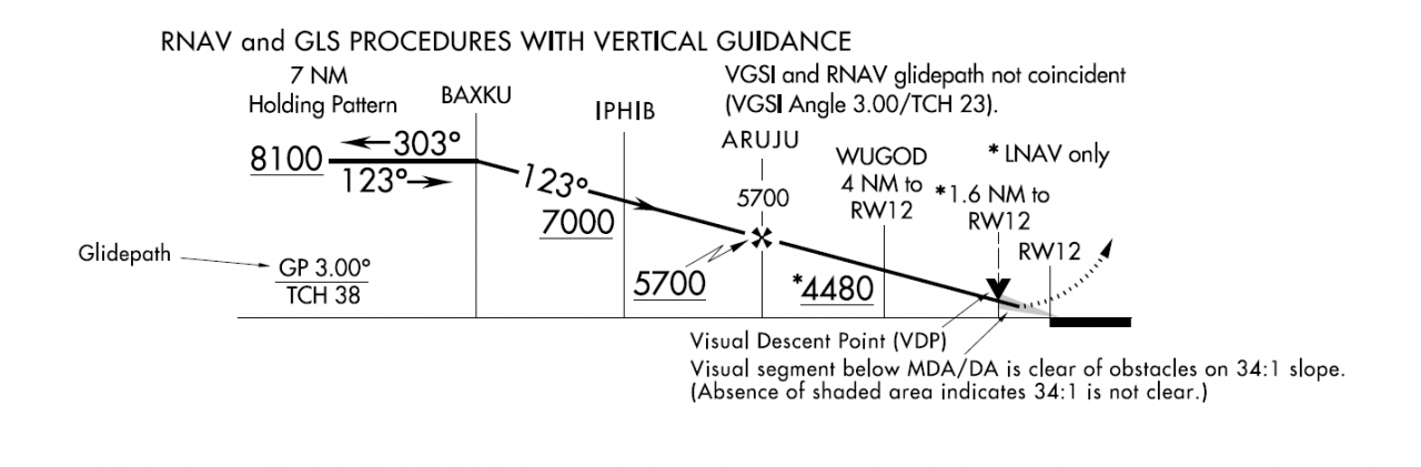
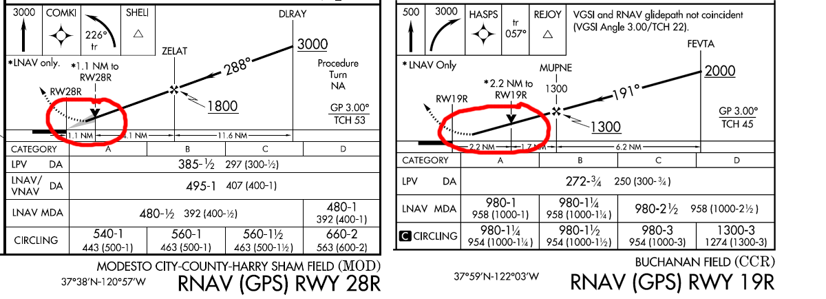
Before we leave the concept of VDPs together, here are two more bonus points. First, do you know what the shaded staple on the non-precision approach with VDP means?
Second, do you really have to compute VDP and annotate it on the chart, if it is not charted?
Circling
Since the main problem was descent to landing from straight in approach, why not circle to land? Remember that circling to land does not mean you have to land on the opposite runway, you could simply enter right downwind to 30 from overhead.
Right, so you just need to ask for circle to land, but before keying the mike you decide to check minimums for the circling approach (look at the chart above).
Wait, where are the circling minimums? A non-precision approach without circling minimums? Indeed, it seems that approach designers forgot to define them. Or perhaps they didn’t forget it, you just forgot to check them before starting the approach. How about the other approach, RNAV Y?
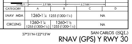
Yes, that one has circling minimums, but MDA is higher, so once you descended below on RNAV Z (which has lower minimums), you are essentially committed to missed approach. Notwithstanding the fact that if you wanted to fly RNAV Y with circle to land, you should have requested that, instead of simply asking for an approach with the lowest minimums.
If you had computed VDP before even starting the flight and annotated it on the approach chart, you would have known that requesting RNAV Z was a losing proposition. After listening to ATIS, you would have proudly said: requesting RNAV Y circle to land 30 and waited for the controller to come back with you want what? – after initial surprise they would have approved it though.
That’s nice, but isn’t it kinda silly? SQL is my home airport, I know exactly where the runway is looking at the ground below me, I know there are no obstacles on final, isn’t it somewhat over the top to have to circle to land? In this case, it is required because doing otherwise would be illegal, but it wouldn’t necessarily be unsafe.
Contact approach
This is a poster child for the somewhat obscure contact approach. AIM 5-4-25:
Pilots operating in accordance with an IFR flight plan, provided they are clear of clouds and have at least 1 mile flight visibility and can reasonably expect to continue to the destination airport in those conditions, may request ATC authorization for a contact approach.
We have 1 mile visibility? Check. We can reasonably expect to continue to the destination airport? No clouds and we know where the airport is. Check.
AIM also goes on saying that the airport must have an instrument approach, which it does and we cannot use it to request approach to one airport and fly to another, which are not planning to do. Finally, there is no missed, which is fine, because if you have to go around, we can do it visually.
Now you can reply in your best imitation of the airline captain voice: Requesting a contact approach to San Carlos. Don’t be surprised if a controller says you want what? They are not used to those and he may go back to manuals to read about it, so it is best to request it sufficiently early.
Bonus points
Why are there two approaches to the same runway (Y and Z) in San Carlos and what are the differences? You already know some answers.
- Z has MDA of 900 and Y has MDA of 1260
- Y has circling minimums and Z not
- Look at the Missed Approach: Z requires minimum climb of 302 feet per nm to 5400
The last point is the real reason why Y exists; it doesn’t have that requirement and can thus accommodate lower performance aircrafts. 302 feet per mile is 450 fpm at 90 knots, which pretty much everybody should be able to do, but it does exceed standard 200 feet per mile, so here you go. Points 1 and 2 are just consequences of 3.
What is that shaded staple? Head straight to Aeronautical Chart User Guide (page 108) for explanation:

Absence of shaded area indicates that visual segment below MDA is not clear of obstacle on 34:1 (1.7°) slope.
Finally, do you really have to compute VDP? You should, but if you find you forgot and you are on a LNAV+V, the advisory glidepath will bring you to MDA precisely at VDP. Just don’t make a mistake of using MDA as DA, you are not allowed to dip below it.