Activate what? Vectors where? There seems to be considerable confusion about these words in the context of instrument flying, and this article will hopefully help clear some of it up. We will start with simple cases of don’t do it and move to more complex.
Activate Approach
All Garmin navigators, starting with the GNS430, have a menu function called Activate Approach.
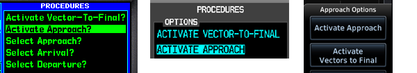
When should you use it? To answer this question, ask yourself whether you have ever heard the controller say activate approach? No, and you shouldn’t do it either.
Menu function Activate Approach is strictly equivalent to selecting the first waypoint of the approach and pressing Direct-To.
Remember the statement above, and everything will become clearer. So why shouldn’t you do it? For consistency. If you are being vectored, you will receive an instruction to proceed to a waypoint, which is part of the approach (it may or may not be an initial approach fix), or to intercept a leg, which is also part of the approach. Both of these will activate the approach. I believe it is clearer to explicitly tell your navigator where you want to go rather than relying on an implicit rule.
In January 2003, a Cirrus SR20 crashed on approach to KHRV because the pilot selected Activate Approach. The aircraft, which was descending at this point, was already past the IAF, so the autopilot dutifully turned the aircraft 180 degrees and flew into a side of a hill.
Vectors Transition
When you load an approach, you are presented with a menu of transitions, and the first one will always be vectors. Here it is simple; also, never choose vectors. Consider, for example, RNAV 28R Y OAK, and you are being vectored from the East.
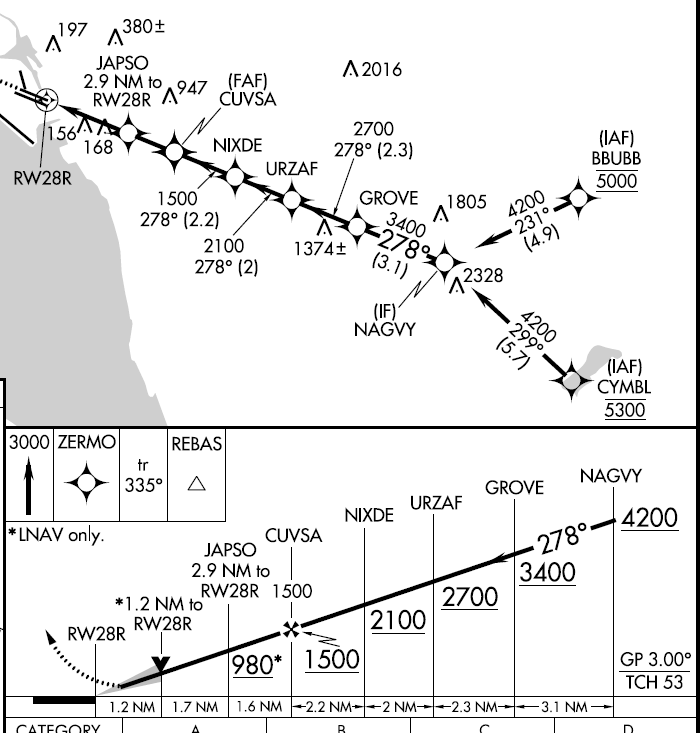
It seems like a good idea to select VECTORS as the transition; you are being vectored after all. However, see what happens to your flight plan when you choose VECTORS transition.
You have all the waypoints on the approach, but the course guidance is missing. These waypoints are step-down fixes, and being on the glidepath does not guarantee that you cross them at or above, so you must identify them, and at this point, the only way to do it is by distance. You would need to add all the segment lengths to figure out when you are at NAGVY. If you use Jepp charts, you are in luck; they have cumulative distance from MAP.
If, instead, you choose the BBUBB transition, your flight plan will include guidance for all the approach waypoints.
In fact, VECTORS transition is equivalent to using vectors-to-final (VTF), which we will discuss in the next section. Even if you are a VTF aficionado, you should still not choose VECTORS transition, because you can always switch back to VTF (PROC->Activate-Vectors-Final) at a later stage when you need it.
Activate Vectors to Final
I left the most fun one for the end. Given what I wrote in the preceding section about vector transition, you may reasonably ask why anybody would want to use VTF. It seems that a much smarter idea is to always activate an approach directly to a fix that is part of the approach, or to activate a leg. There is some truth to this statement.
However, consider what happens when you intercept the final approach course somewhere between NAGVY and GROVE. You now have 3 step-down fixes to fly: each time, change the altitude selector, press VS, set vertical speed, adjust power, then adjust power again as you level, all the time watching the ETA to the next waypoint, so that your descent rate is sufficient. There should be a better way, and there is.
I said three step-down fixes, but I see four: GROVE, URZAF, NIXDE, and CUVSA. Ah, but do we need CUVSA? The key to the answer is knowing when the glidepath appears on the PFD: it does when the FAF becomes an active waypoint, which occurs at NIXDE. So you level off at NIXDE and intercept. What if we make CUVSA the active waypoint sooner? That’s exactly what VTF does, so you decide to activate vectors to final as soon as you intercept the final approach course before GROVE. Now, the glidepath will appear right away, and you will intercept it past GROVE, because GROVE at 3,400 is actually below the glidepath. Great, but what about those step-down fixes? You just lost all the guidance to them. You could use the distance information present on the chart to compute where each fix is and identify it, but that seems complicated.
Do you need to watch for these step-down fixes? You check, and they are all comfortably below the glidepath. Yes, they are on the standard day, but remember that the glidepath is a geometric construct, which is constant. At the same time, the step-down fixes are baro- and temperature-dependent, so on a really hot day, you may actually find yourself below. ASRS has plenty of submissions from airline pilots who busted ILS to Chicago step-down fixes precisely because of that. There must be a better way, and there is, but only if you fly the right equipment.
If you have a Cirrus Perspective, it has a VNAV function. Don’t activate vectors to the final; arriving at GROVE, set 1,500 in Altitude Selector, press VNV on the autopilot, and the airplane will descend nicely on the VNV glidepath. You still need to watch the altitude of step-down fixes, but that’s just monitoring. When over NIXDE, the glidepath will show as before, and the airplane will switch to it; you have nothing to do but monitor altitudes for step-down fixes, which are now identified, and adjust power to maintain 100 knots.
If you have an airplane with dual GNS430, for example, and an older Avidyne Cirrus, you are also in luck. You can activate vectors to final on the GPS#1, but not on #2, which you will use to identify the step-down fixes. You must disable automatic crossfill for that to work.
Note that all that gymnastics is not necessary on ILS; you can simply press CDI anytime when on the final approach course to switch to green needles (Perspective), and you will see the glideslope, so there is never a need to activate vectors to final in that situation.
Before leaving this topic, I’d like to point out one other advantage of active vectors to final. Perspective will reload the localizer frequencies for the active NAV #1 and #2, so you messed them up; it will fix them.
What happens when FAF becomes the active waypoint?
Much of what I wrote may be made simpler if you remember what happens when the FAF becomes the active waypoint:
- On the RNAV procedure, the glidepath will show. It will not show up earlier, so there is no point worrying why you are not seeing it.
- On ILS, Perspective will automatically switch from GPS (magenta) to the ILS (green) navigation source. You can, of course, switch earlier manually.