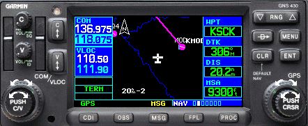
Many pilots unfamiliar with GNS430 put it on the map page and leave it there. Like this. Now, it is pretty simple, all you have to do is follow the magenta line.
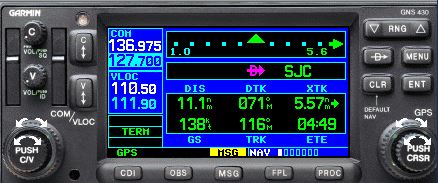
However, there is a good reason the default page is called default page – that is the page you should be displaying almost all the time, because it contains a lot of valuable information.
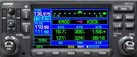
Here is what a quick glance at the default page tells you:
- You are flying the leg from KMOD to KSCK.
- You are 16.7 nm from Stockton (DIS) and at the current ground speed of 121 knot (GS)s, you will be there is 8 minutes, 16 seconds (ETE).
- The desired track from KMOD to KSCK is 306 (DTK) and your current track is 324 (TRK), which means that you are intercepting at 18 degree angle.
- You are currently 1.58 nm from the course you want to intercept (XTK).
Very few people go to the trouble of changing data fields to display XTK and that is another little tidbit of situational awareness. Note that 1.6 shows also at the top right, but I do prefer to have it in the data field.
Why is all this interesting? For starters, if you follow the course, then your actual track (TRK) should be the same as the desired track (DRK). Let’s say that DTK is 300, TRK is 305 and XTK is 0. This means you are exactly on course, but unless you do something, you will fly away from it. All you need to do is to turn left 5 degrees. Note that you don’t have to guess how much to turn, the box tells you the exact number. Also, the wind doesn’t matter, because we are talking ground course, not headings. Isn’t that helpful when you are tracking the localizer?
In another example, let’s assume that you are intercepting a course at 45 degree angle. When are you going to turn so that you don’t roll out of the turn exactly on course, without over- or under-shooting? A useful rule of thumb says that 90 degree turn at standard rate of turn and 120 knots takes half a mile. When you are half a mile from the course as shown by XTK, you can start a nice half a standard rate turn and roll out 30 seconds later.
So why would you fly with map page? You probably have a much better map on your iPad anyway, right? There is nothing wrong with switching to the map page for a quick peek, if you think you need that additional shot of situational awareness, just don’t stay there too long.
Do you know how to quickly get to that page? Yes, it is written on the panel, press and hold the CLR key.
Christophe Jacquet
Thomas,
Good stuff.. thanks for posting.
Two questions:
– Since the distance to the track is indicated in the top windows (shown as 1.6 on the screenshot), why do you still recommend to use a field at the bottom to have the XTK?
– On what doe the 1.0 shown on the left indicates?
Thomas Daniel
Chris, distance is indicated numerically when it exceeds one mile. Below 1 mile (en route), you get 1.0 numerical value (as on the left) and the course deviation indicator. Since each dot is 0.2 miles, you can figure out how far you are without XTK, just by looking at which dot the indicator is positioned. However, this gets more complicated when you are flying an approach and the navigator changes the scale for full deviation, so now you have to calculate. I prefer to always have numerical value under XTK, but it is a personal preference.